 2 hours ago
8
2 hours ago
8
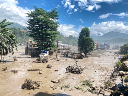
The images from Nepal stopped Daniela Schmidt in her tracks. A geologist at the University of Buenos Aires in Argentina, she watched the deadly flash floods on 26 August tear through everything in their path, people running for their lives as the water and debris swept over the landscape.
“I had never seen anything like it,” she says. “This was one of the most catastrophic events on a global scale related to these glacial floods.”
-
The aftermath of the Nepal floods in Nuwakot district, 26 August. Photograph: Xinhua/Shutterstock
The shock deepened as the first geological figures emerged: the volume of glacier ice and rock that had collapsed and the scale of the resulting flow. Schmidt began comparing them with the cases she had studied during her PhD. Very few glacial lake outburst floods, she realised, had reached anything close to this magnitude.
But Nepal also changed the way she saw her own work. Schmidt studies the glacial lake outburst flood (Glof) that could occur at Laguna Torre, in Argentina’s Santa Cruz province, and its potential impact on El Chaltén, a nearby town known as the country’s trekking capital.
The disaster already exists on her computer screen: data, models, flood simulations and maps. According to her studies, if the northern slope of Cerro Solo were to collapse into Laguna Torre, at the base of the Torre glacier, a massive volume of water could travel the 5 miles (8km) to El Chaltén in 20 minutes, sweeping along logs, rocks and sediment.
The discharge could reach 1,769 cubic metres (62,472 cubic feet) a second, rushing down the Fitz Roy River towards the town and inundating its only access bridge and other critical infrastructure. For anyone in the valley, those 20 minutes would be the window to reach safety. “It is the worst-case flood scenario,” says Schmidt, adding that, in the most conservative analysis, the flow would take between 45 minutes and an hour to reach the town.
“You can’t say it will happen on a specific day or at a specific time, but society needs to be prepared,” Schmidt warns. “It is going to happen.”
-
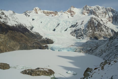
Sustained melting has created a second body of water within Laguna Torre, which poses a risk to the town below if the glacier collapses. Photograph: Javier Rasetti
The threat was already changing how El Chaltén prepared for the future, but the disaster in Nepal has brought these risks to the forefront. Although the scale of that event and the El Chaltén scenario differ, Schmidt sees a similarity in the mechanism: a mass suddenly plunging into a body of water can trigger a flash flood with immense destructive power.
Authorities from Los Glaciares national park and the municipality of El Chaltén, along with local organisations and various scientific institutions, are working to develop the country’s first Glof early-warning system and draft evacuation protocols.
“We are preparing for the worst-case scenario,” says Enrique Rivero, El Chaltén’s secretary of government.
The silhouette of Cerro Solo is unmistakable. The vertical granite peak, rising to 2,121 metres (6,959ft) above sea level, is reflected in Laguna Torre amid floating icebergs. That is where the risk begins.
-
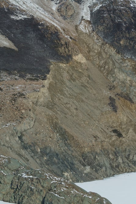
As the ice on the Torre glacier retreats, the surrounding slopes can also shift. Photograph: Javier Rasetti
The Torre glacier is estimated to have lost 4 sq km (1.5 sq miles) of surface area, while its ice thinned by 60-70 metres between 1952 and 2023. As the ice retreats, the balance of the surrounding slopes also shifts – a process researchers describe as a “release of stress”.
This transformation is visible in landslides and rockfalls that leave scars across the mountainside. Between 2002 and 2023, the volume of displaced material increased, while the speed of movement doubled. “It moves slowly, but during heavy rainfall or high temperatures, it accelerates in pulses,” Schmidt says. “As the slopes become unstable, they can slide, dumping a large volume of material into the lake and causing it to overflow. It just needs a trigger.”
Her models contemplate landslides involving between 8m and 13m cubic metres of material. If a mass of that size were to collapse into Laguna Torre, it could generate a wave up to 5.8 metres high. The wave would travel across the lake at approximately 20 metres a second, reaching the Fitz Roy River in just one minute and 40 seconds.
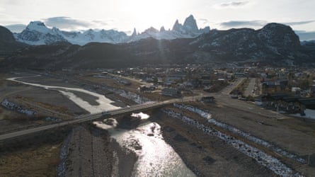
Under the most conservative and the worst-case scenarios, a flood would eventually reach the bridge and render it unusable. The bridge is the only land access connecting El Chaltén to provincial route 41.
The municipality has already ordered the dredging of the river channel and the clearing of the riverbed beneath the bridge. “But now we are being told that the water level could rise by up to 5 metres, which suggests the bridge could be swept away,” Rivero says.
-
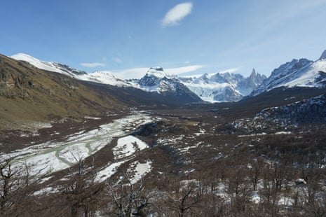
Fitz Roy River in the Laguna Torre valley. The river could rise rapidly by up to 5 metres if a glacial lake outburst flood occurred. Photograph: Javier Rasetti
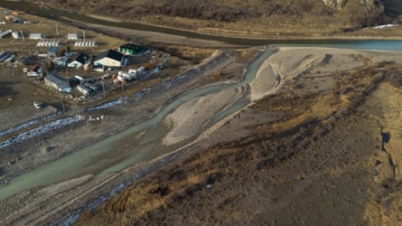
The flood could also affect critical infrastructure located just metres from the riverbanks, including gas and power plants, schools and homes. Discussions have already begun on a contingency plan that considers, among other measures, potential relocation.
“Gas supplies coming from Río Gallegos – the capital of Santa Cruz province – would be cut off, leaving us without heating,” says Paula Chaparro, a member of the El Chaltén Mountain Guides Association. “If the power grid fails, El Chaltén relies on generators running on fuel oil; if they run out of fuel, we lose electricity. It’s a problematic chain reaction.”
If the event were to occur in summer, peaking in December to February, the town would be cut off, with more than 27,000 people – locals and tourists alike – stranded in the town. At present, according to residents, there is no signage indicating evacuation routes or instructions, nor do hotels warn guests about the risk.
The risk has been known for years, but the available instruments could not precisely determine how quickly the slope was moving or, crucially, how much water could be displaced in a collapse. “We’ll have to wait and see if it happens” was a common reaction among locals, says Sofía Bonangelino, a member of Friends of Los Glaciares National Park, an association that manages three campsites.
-
The Fitz Roy River bridge, which provides the only access to the town of El Chaltén. Photograph: Javier Rasetti
Even Horacio Pelozo, the park superintendent, acknowledges this: “The initial studies really weren’t alarming, or anything of the sort.”
However, a key new piece of data emerged, Pelozo says, alongside the measurements of the slope’s movement: sustained melting had created a second body of water within Laguna Torre, the depth of which now exceeds 220 metres. Previous estimates had placed the depth at about 80 metres.
-
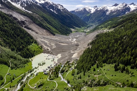
The remains of Blatten in Switzerland after the collapse of the Birch glacier, 29 May 2025. Photograph: Jean-Christophe Bott/AP
Then, in May 2025, an image from the Swiss Alps demonstrated the potential scale of a collapse involving ice and rock: the Birch glacier collapsed on to much of the village of Blatten, burying it in a matter of seconds.
Los Glaciares national park has taken steps to address the risk of a Glof, including relocating the De Agostini campsite, rerouting hiking trails, installing warning signs and establishing an evacuation protocol involving at least 25 personnel to manage potential floods during peak visitor seasons.
The response has expanded to include coordination with local and national agencies, such as the municipality of El Chaltén, in the Santa Cruz province, the Federal Emergency Agency and the Argentine Geological and Mining Service, though no formal contingency plan has been finalised yet.
The El Chaltén city council has passed a resolution to develop an evacuation plan, while a detection system with six monitoring stations – equipped with cameras, sensors and emergency buoys – is in development to trigger alerts via sirens, SMS and email. Yet funding cuts have delayed implementation, with the estimated cost of $220,000 (£163,000) exceeding the park’s current capacity, as noted by Eduardo Marino, a former secretary of government for El Chaltén.
“Let’s not talk about Glofs, because it will scare off tourists” – that concern is circulating around town. And it is not hard to understand why – a large part of the community relies on tourism for its livelihood.
-
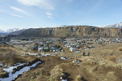
El Chaltén seen from the beginning of the Laguna Torre trail, which is popular with hikers. Photograph: Javier Rasetti
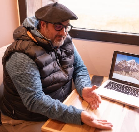
Marino owns a hotel; Bonangelino runs a bookstore, rents out a cabin, and works as a ski instructor. For them, as for so many other residents, protecting tourism also means protecting their own livelihoods.
-
Eduardo Marino who owns a hotel in El Chaltén. Photograph: Javier Rasetti
Marino was asked to drop the subject until the summer season was over. He refused. He knows a day of heavy rain or exceptionally high temperatures could be enough to trigger an event they are not yet prepared for.
For those who work in the mountains, information is key to risk management. “Closing down isn’t the solution,” says Chaparro. The idea, she says, is to offer alternatives: different trails, different activities. “It’s not about being afraid; it’s about staying alert.”
When her colleague Ariel Puntin speaks to local people about the threat he still encounters some who doubt the mountainside could collapse. The problem, he says, is that the gap between “it could happen today” and “it might never happen” is too wide to easily learn how to live with the risk.
-
The Fitz Roy River flooding could affect gas and power plants built near its banks, as well as homes and businesses. Photograph: Javier Rasetti
For Schmidt, the events in Nepal should serve as a wake-up call, but also as an opportunity to improve the town’s preparedness. “The community and the tourists must be protected and kept safe in the face of this new reality of constantly changing glacial landscapes,” she says.
Bonangelino has noticed a positive shift in recent months. As the studies’ findings have been explained to the community, she says, acceptance has grown that the phenomenon is real and that preparation is necessary.
“We are a resilient, responsible community that cares deeply about its environment,” she says. “We rely on tourism, and we aren’t going to neglect it.”